My Journey began in 2016 when I made the fateful decision to sign up for the award at my school, little did I know back then that it would lead to some of the best memories & experiences of my life...
The Award
The Duke of Edinburgh's International Award (DofE for short) is a program designed for the development of youth aged 14-25 and is comprised of three award levels; Bronze, Silver & Gold. All three award levels feature Service, Skill & Physical Recreation components which participants are required to complete an hour of each week for a set period of time and two Adventurous Journey. The Bronze level of the award can be commenced at 14 and features 3 months of Service, Skill & Physical Recreation though the participant must choose one to be their major and must undertake 6 months worth of that component. The Adventurous Journeys for this award level are required to be of at least 2 days and 1 night. The Silver Award level can be commenced at 15 and sees all three components have to be undertaken for 6 months with Adventurous Journeys now required to last 3 days and 2 nights. Finally, Gold requires the participant to be at least 16 and they must complete 12 months of each component, two Adventurous Journeys of 4 days and 3 nights as well as requiring an additional Residential Project to be completed which must last 5 days and 4 nights.
The Expeditions
For me the Adventurous Journeys were what made months of recording your service, skill & physical recreation components in the online record book all worth it. To be able to come together with a bunch of your classmates who had also been working away at the award and be able to go out on expeditions into the great outdoors; you knew they were memories that you would never forget even as they were being made. The bus ride home from each expedition I always knew I had to be there for the next one as on those trips when nothing else mattered but going from point a to point b was when I felt most alive, free from the monotony of everyday life. Learning this about myself, learning that as much as society rumbles on and the everyday grind can feel never ending that there's a whole other world somewhere out there past the suburban sprawl in the wild landscapes where you can seek refuge from your worries whatever they maybe and purely just exist for the moment, I will be forever grateful.
Bronze
Mount May: 16-18th of June 2017

My very first Duke of Edinburgh trip I was in year 9 and I remember that my hiking back was ridiculously heavy to the point I could barely carry it but luckily I didn't have to as the bus was able to pull right into the campsite albeit with some difficulty on the last corner. Waterfall creek reserve campground would serve as the campsite for both nights and from the camp we would venture out with day packs. I had been camping with my family growing up but always in quite commercialised holiday or caravan parks so this was a step up. I was in a small group just four students one of them being my best mate who I was also sharing a tent with and a student leader and a past student to make sure we didn't get in too much trouble. The goal of the trip was to venture up Mount May in the North Western part of Mount Barney National Park the mountain has two peaks the main peak to the south sits at 835m while the smaller Northern summit is 786m. After dropping our gear and finding out our group we set off up the 4wd Waterfall Creek Road which circled round the peaks to the West before climbing to a saddle South of the peaks. Along this section of trail the infuriating Triangle Game a Duke of Edinbrugh classic was first introduced to us by the older students thankfully my mate cracked it after about half an hour. The ascent to the saddle South of the peaks was particularly heinous due to the loose rock that made up the road and thus the turn off to summit was welcomed even if it was steeper again. A fun little scramble was reached and passed one by one before reaching the summit of Mount May we had caught up with other groups on the way up so there were a few off us at the top so an elongated lunch stop was had while waiting for the groups to spread out. When we got going our group dropped off the North side of the summit and while cutting back South on the Western side of the summit heading towards the saddle between the peaks we encountered cliff bands which were passed by continuing South to the saddle which once gained provided an easy path to the second summit. Now this is where the day took a turn from the Northern summit all that was left to do was descend North off the summit back down to camp to complete the loop but a previous bushfire and subsequent scunge growing back had left the path hard to find off the top. Of the groups that went our way round the loop we would be the one group to return in daylight. It was latter determined the two groups that eventually made it back to camp hours after the others had dropped of the North Eastern side descending back into the gully between the two peaks where as we dropped off the North Western side and had a very different experience. To this day the best bush bash I've experienced the burnt exposed slopes we hurtled down with ease dropping straight down toward the road we could see far below us. Our progress only momentarily halted by a cliff band before using a fold to continue our trajectory straight down. We would pop out onto the road we had walked up earlier this morning with only a short stroll back into camp. We had arrived before anyone else thanks to our shortcut and so set up camp and proceeded to have dinner while waiting for other groups to arrive. This was my first proper use of a Trangia to cook my dinner and was also when I was first introduced to Jimmy's thunder box. This contraption is a hinged piece of metal that folds out to become a box with a wooden lid and basically forms a rudimentary toilet. So, a hole is dug then the thunder box is placed on top and business is done and then at the end of the camp or if the hole is getting a bit full it is filled in. These two devices the Trangia and thunder box would prove to be ever presents on Duke of Edinburgh expeditions. The last of the groups arrived in the increasing darkness of the night. Due to the first days mishaps none of the groups went the way we went yesterday due to the problems finding the way down with all groups instead heading straight up and down the Northern path we had failed to find yesterday. This would turn out to be the opposite of yesterdays experience as an injury in another group forced an amalgamation and the new members were significantly slower. When we eventually reached the Northern summit we played cricket on top of the mountain and I was dared to eat some mountain dirt (great memories, less great taste). We then made our way back down to camp without any deviation from the trail this time and spent the afternoon at camp playing another modified game using a very circular rock dubbed 'Ling' as a rugby ball this 3.5kg shot put of a rock would go on to come on each and every DofE trip I did as a student. It was often joked that we should've picked a smaller rock to adopt but the incredulous looks I got when pulling Ling out of my hiking pack a few days into a multiday hike more than made up for the weight. The rest of the evening was passed sitting and chatting on a large fallen log or by the fire or by going up the creek to the mini waterfall to get water. The final day was a pack down of camp and an early departure. The bus ride back was full of excited chatter.
Mount Joyce & Lake Wyaralong: 1-2nd of September 2017

The bronze qualifying trip was a short overnighter lasting only two days. The walk into the camp was pretty uninspiring as it consisted of following a fire trail through dry scrub on the edge of Lake Wyaralong which at the time was experiencing a blue green algae break out. The lunch time stop and 'navigation challenge' wasn't much to write home about either as it consisted of just walking around a BMX trail loop. Things were starting to look up though when we made it to Ngumbi Camp Site as that night there would be no need for tents as we would be rolling our sleeping bags out on the floor of one of the two old farmhouses. This made for one unique night of camping as the boys and I found a room to claim as our own and proceeded to make it home for the night ahead. With the minimal set up complete the boys and I, ran down the trail to the lake which at present closely resembled Shrek's swamp and any ideas we may have had of a swim were quickly dismissed. We proceeded to explore around poking a near by puff ball with a stick and watching it belch spores. Having returned from the lake it was time for dinner and an early night as tomorrow morning we were to climb Mount Joyce (469m) for sunrise. Predawn rises are never pleasant though being able to get ready in the old farm houses was certainly preferable to a tent. First light was encountered on the ridge just below the summit with breakfast and the view above greeting us at the top (the farmhouses can just be made out in a clearing in the centre of the image). We then proceeded Westward along the ridge for our second 'navigation challenge' this time it was actually a challenge as we were to bush bash South off the ridgeline and make it back to camp. Our group waited to be released and once we were we straight-lined it down through the bush making it back to camp in a good time and chatted with the other returned groups while we waited for the slower groups. The walk out back along the way in was once again unremarkable aside from a game devised at lunch time. The game consisted of running as far as you could along an embanked BMX ramp before succumbing to gravity. The teachers didn't like the game as they feared a broken ankle wasn't far away though no suck injury occurred and when it was time to continue the hike out I had come away with the victory managing to get to 14 planks. Now this trip does have the distinction of being the shortest Duke of Edinburgh trip I've been on and if they were to be ranked it would potentially be bottom of the pile. That's not to say this wasn't a thoroughly enjoyable trip with lots of great memories merely just a reflection on the high bar set by other trips.
Silver
Gold Coast Hinterland Great Walk: 10-12th of August 2018

The Gold Coast Hinterland Great Walk 54 kilometres of lush rainforest stretching from Lamington National Park to Springbrook National Park the catch we were doing it at night. In the years since I've heard this expedition be referred to as anything from a nightmare to just a bad idea from the outset but best believed I loved this trip. Starting out from O'Reilly's Rainforest Retreat with the last of the light we had roughly 22 kilometres ahead of us before we could call it a night. By the time we rounded Mount Bithongabel (1195m) the light had well and truly abandoned us though spirits were still high and the night air was full of constant chatter. Two frightening experiences were to come though the first of which occurred when I as the first walker of our group caught up to the last girl in the group ahead of us. Now maybe I have the ability to be able to walk silently behind someone or maybe more likely the girl just wasn't paying much attention either way when the girl finally heard a noise and turned around the last thing she was expecting to see was a face less than a meter behind her. Que the largest real life jump scare I've ever had the privilege to witness. Now the second frightening experience would leave our group reeling backwards as we discovered that lookout is synonymous with cliff in the back reaches of Lamington National Park. We were excited when we saw a sign directing us to a lookout so we raced to have a look expecting to find a manmade structure instead to our surprise we were standing on an unfenced cliff edge with churning fog silhouetted in our head torch light just another step in front of us. Suffice to say we approached with more caution the next time there was a sign to a lookout. Signage just seemed intent on playing cruel tricks on us in the later stages of this hike as we were constantly disillusioned by signs that displayed the distance to Binna Burra in miles rather than kilometres. We would assuming it was kilometres, only to find a sign later on that would tell us we had further to go than the sign we had saw earlier; the miles to kilometres conversion (x1.6) is cruel. When we finally reached Binna Burra well past midnight staff were waiting for us with a hot chocolate at the campfire it was definitely a welcomed sight indeed. What was less welcomed was realising that the tent sites were situated on gravel. Now up until this night it had never mattered that I never bothered to bring a ground mat as laying on the floor of the tent in my sleeping bag was good enough for me but I never imagined we would be sleeping on gravel I mean really whose sick idea was it to cover the floor of a campsite in gravel. To add insult to injury I was also sharing a 'three-man' (really means two man) tent with two large guys who of course both brought sleeping mats. So, I was tucked away against the wall of the tent sleeping on gravel and it was without doubt the worst nights camp I've ever had, I would not recommend. The only saving grace of the night was that there wasn't long left of it and as soon as it was over I was off the gravel floor and over stoking the campfire. As we would not begin hiking again till just before sundown I spent the morning by the fire. The rest of the day was passed by leading each other blindfolded around the sensory trail. Late in the afternoon we began the decent to the Numinbah Valley floor where the one road walk section of this hike would be to get there we would need to walk along the edge of the Numinbah Correctional Facility otherwise known as a prison. Now it seemed not all groups got this memo as an all girls group missed a turn and ended up walking right up to the prison gates rather than just skirting around the edge. Our group found the turn but still had a run in with some inmates of a different kind. Some of our group members had a bit of a hyperactive imagination, mistaking the reflection of the cows eyes in the dark for those of prisoners watching us. When we reached the road we had to wait for the missing group it was quite amusing when we found out where they had been. Setting off down the road some of the group with a less than trepid constitution were once again tested as we walked past an eerie old farm house with some nightlife making noises from inside. Further excitement along the road walk came from the occasional headlights speeding past and timing our dashes across the narrow bridges as not to coincide with them. A late dinner was to be had upon our arrival at the Numinbah Valley Village our dinning table would prove to be the sceptic tank outside the Numinbah Valley School of Arts. With questionable combinations of condiments on wraps consumed we took off along the most aptly named fire trail I have ever walked. Headtorches were no longer needed as the scrub on either side was full of glowing coals and patches of fire from a controlled burn. It was enough to take the breath away; literally in the case of the asthmatics in the group whose lungs were struggling to hack it due to the smoke. Upon reaching the end of Chesters Road we were greeted by the 4wd support vehicle which gifted us 20L drums of water which we would need to carry into the camp. Threading large sticks between the handles we were able to carry them down to and across Waterfall Creek and up the other side to Woonoongoora Walkers Camp. The hard work was well and truly worth it as Woonoongoora was a special campsite indeed. The cleared site on the hillside was devoid of trees (except for one impressively large dead tree further down the hill) making for a brilliant view of the stars. It was also home to nature's own mattress a patch of soft long grass which when the tent was setup on top of, the floor of the tent would sunk into it under your body weight. Looking forward to sleep the night still had one more surprise instore for us as a teacher got everyone together in their sleeping bags to lie on the hillside and he shared his knowledge of astronomy leading our eyes to distant constellations. Slowly people dispersed to their tent when they couldn't keep their eyes open any longer and having slept the previous night on gravel I was well and truly ready for bed. Woonoongoora didn't disappoint as I enjoyed one of my best ever sleeps in a tent thanks to the mattress like qualities of the grass. The final day was short and straight forward and would require no more night walking with the days main challenge greeting us immediately as we left camp. Over 900 steps awaited us as we would be climbing over 400 vertical metres up to Apple Tree Park which a sign informed us would be greater than scaling the Gold Coasts massive sky scraper the Q1 which only reaches 322.5 metres. While this is a rude wake up call the 900 steps actually prove of great assistance and the task isn't as onerous as one might conceive it to be. The vegetation changes on your journey upwards becoming lusher as you reach Apple Tree Park which though not on the Springbrook Plateau proper is still located at ~560 metres above sea level. You would be forgiven for thinking this would be the end of the days significant altitude changes though you would be wrong as the trail proceeds to drop back down to ~370m before winding back up to ~600 meters above sea level on the plateau proper. We would stop for morning tea at Apple Tree Park before attempting the next decent and re-ascent. We crossed the road and briefly followed a powerline break before descending down to the West Branch of Little Nerang Creek the next section following the creek upstream to the base of the impressive 100m Purling Brook Falls (pictured) is one of the most enjoyable sections as you follow the creek past numerous cascades and the Warringa Pool before reaching the big boy. The last part of the Great Walk follows the Purling Brook Falls Circuit which I have done countless times but it felt very weird to be walking it on a Duke of Edinburgh expedition. The journey ultimately was a return home in a geographical sense as we started a 2 hour bus drive away from school at O'Reillys and were now a mere 30 minutes away though we had definitely gone the long way home spending nearly three days to reach this point. The journey also brought us back to civilisation from not seeing a soul in the depths of the night in the heart of the mountains to passing groups of walkers every few minutes as we neared the end. It was definitely a trip to remember but I have never felt so completely foreign in somewhere so familiar.
Moreton Island: 21-24th of September 2018
Arriving at the Tangalooma Wrecks we disembark and take our first steps into the sand which we won't be able to get away from for the duration of the trip. Determined to ensure that we immediately embrace the sand we are led straight to a giant sand dune and told to drop our packs and have a go at reaching the top. The views from the top out over the dazzling blue water alone was well worth the effort and that's without taking into account the joy of hurtling down the dune. Once down it was time for the groups to split so we said our goodbyes to the other half of the group knowing we would see them back here in three days time with lots of new stories to share (Note: though we are following the same path in the opposite direction due to differences in campsites for the second night and what time the groups leave their campsite on day three the groups don't cross paths till the end of the trip). With goodbyes said our South bound group sets off down the beach. Due to most of the day being spent in transport it's already late afternoon by the time we pass the Tangalooma Resort and we can already see the splashes of dolphins as they get ready for their sunset feed at the resort jetty. Before too long we see a marine warning sign mounted on the hillside which is our sign to turn inland. We climb the steps to the sign and have dinner as we watch the sunset. With our headtorches retrieved from the depths of our packs, once again we were hiking at night. We headed into the bush though before long we would leave it behind again as we climbed up a sandy ramp and dropped into The Desert.
The Desert was a big sandy bowl almost devoid of trees except a small cluster at the bottom and was rippled with large dunes. What I would consider a hikers worst nightmare if visited during the day time was at night a hikers paradise. Instead of a large melanoma producing frying pan it was a breezy amphitheatre for watching the stars and the formidable dunes were silent waves to play on. An hour at least was spent in the desert and when we left we felt rejuvenated rather than dishevelled what lay ahead of us though was less refreshing. In order to join the Rous Battery Track which we would be taking to camp that night we would first need to slog our way through soft slushy sand churned up by 4wds. Needless to say not the most memorable section of trail though did introduce us to our first slithery friend of the night a python who didn't think much of our so called trail either so quickly slinked off into the scrub. Along the course of the 9.8km Rous Battery Track we saw two further pythons enjoying their evenings which proved to be the highlights of the night as the track was rather monotonous due to unchanging scenery. Some of the group grew tired somewhere along the track and thus a break was taken which gave me even more time to consider how nice it was to be hiking at night and how hot the next three days could be. We knew we were finally close when some off shoots started appearing on the trail of which we were told we would explore tomorrow morning so we continued down the path as it finally descended towards the ocean which we could hear in the distance. When we made it to camp not long was wasted before everyone was sound asleep.
We woke to the sound of waves on our first full day of island life and went down to see the beach in the morning light. The long white curve of the beach stretch uninterrupted to the North for many kilometres and would be our track for the days walk. Before the days walking began there was breakfast to be had as well as the promised exploration of the Rous Battery ruins. Rous Battery was commissioned to protect Moreton Bay during world war two from the threat of Japanese marine attacks. These ruins provided the perfect opportunity for the dukes captains and past students who were on the trip with us to introduce us to a classic and on running joke of performing jump scares from the dark corners of the ruins. This was great fun and as we made our way through the assortments of pillboxes and barracks similar copycat attacks occurred. When we reached the highest ruin we climbed atop it's roof and witness to the stunning views it had to offer (pictured). After soaking in the views it was back down to camp and after we were led through some beachside yoga we set off up the beach.
At first we saw some outlining remains of the battery in the hillside before leaving it and any signs of modern world behind as we were left with just the Pacific to keep us company. The featureless beach gave very little clues as to how far you had come and how far you still had to go giving you the illusion that either the beach was never ending or you had simply been walking in quick sand the whole day. The walk was punctuated by the occasional 4wd whizzing past as it travelled its way along the beach at a much faster pace than we did. The most memorable moment of the days walk came when my mate and I at the head of the group came upon the body of a turtle decomposing in the sun. Covering our noses from the stench we were about to move on when we heard an excited squeal come from behind us as a girl rushed to see the cute turtle. The look of horror on her face when she got close enough to be able to see the flesh peeling of the turtle was considerably amusing needless to say when we came across another turtle a few hundred metres later she didn't rush to see it. It was late afternoon when with great relief we finally reached our camp for the night nestled in the dunes just back from the beach near the Eastern entrance to Middle Road.
I was tasked with the setting up the thunder box which at this location proved interesting as there wasn't an apparent location, a small bush proved to be the best privacy screen available. With the location found the engineering work began first clearing a spot and levelling out the ground and then extracting enough sand to make a large hole. Now don't get me wrong this first toilet was no masterpiece but I think enough promise was evident that I was often given the reigns in future toilet construction endeavours. Either that or no body else wanted to toil away digging a whole at the end of a long day. With camp set up dinner was had and after we went down to the beach to play some games. This is when we were introduced to the another Duke of Edinburgh classic, Mafia. Many rounds were played before it was eventually time for bed.
Day three once again began with sunrise over the Pacific Ocean as we enjoyed our last moments on the Eastern side of the island as today we were to Journey back across the islands interior. The big ticket item of the day was climbing the Southern Hemisphere's tallest vegetated sand dune Mount Tempest (280m). To get there we would head West on Middle Road, again the soft 4wd track proved to be less than enjoyable for walking though before long we were turning North on the Telegraph Track. We gradually began to climb and when we reached the turn off to Mount Tempest we had already climbed roughly half the mountains prominence having started at sea level this morning. Now the Southern Hemisphere's highest vegetated sand dune is hardly the most prestigious of monikers and at only 280 metres its hardly towering but the 360 views this peak offers are quite incredible. Though I would suggest not climbing it in the middle of the day as we did. The most distinguishable memory from this visit to Mount Tempest isn't of the stunning views but of the heat. The day was impossibly still and lunch on the summit proved to be less than enjoyable as 360 views also comes with no shade. This would also prove to be the experience that curbed my cravings for Carmen's nut bars as it turns out once you eat about three boxes worth in two and a half days you don't want to eat the remaining two boxes in your pack or even the one in your mouth. As my body decided to reject what I was offering it and instead refused to swallow maybe the dehydration and stifling heat was partially to blame but I still don't look at Carmen's nut bars quite the same way. Despite the stunning views it was definitely a relief to get off the summit though as they say it was out of the frying pan and into the fire.
Now I preface this by saying that the two times I have walked the Telegraph Track since it has been fine but on this day it was hellish. The heat was stifling along the exposed trail we would be walking along all afternoon and not only that but you could see the white shimmer of the trail kilometres in front of you plunging up and down hills. The finish was the one part of the trail you couldn't see for kilometres in advance and when we finally stumbled upon it we hadn't reached salvation yet as this is where we would wait as we were to be ferried by 4wd in groups of four to our campsite for the night. Each round trip took at least half an hour and where we were sitting and waiting surprise surprise had no shade. Everyone was praying that they would be selected in the next draft. Eventually my turn came and the 4wd ride was a great change of pace as we were now whizzing along the sand with our heads bumping against the roof as air time was achieved. The greatest part of the car ride though was hands down the air con. The car eventually reached the nights campsite and we were bundled out as they sped off to collect the next draft of students.
Comboyuro Point campsite was a nice taste of luxury for our last night of the trip, a developed campground with a toilet block and lovely calm waters to swim in. We rushed to set up our tent and get into our swimmers before charging down to the water to cool down and watch the sunset over the mainland. Of particular interest on the horizon was the hulking shapes of the Glass House Mountains and the lights of Brisbane flickering on as the sun went down. Again the night was passed playing mafia on the beach as the boys were consistently voted out by an unspoken alliance amongst the girls perhaps our antics had finally tested their patience one too many times.
The final day would prove to be quite cruisy as we were to head straight South along the beach back to the Tangalooma Wrecks while the other group would have to be up early to complete all the kilometres we had covered on the first day of our journey. So we started late and made our way down the beach past Bulwer and then past Cowan Cowan where there was scattered remains of the Cowan Cowan Battery lining the beach. We rounding Cowan Cowan point and there wasn't long to go making it back to the sand dune we had climbed on the first day with plenty of time to climb and swim before the other group and the ferry arrived.
The journey back proved to be quite enjoyable again sitting up in the open air level though this time watching Moreton Island grow smaller and smaller behind us. The ferry made it back to the Port of Brisbane with the last of the light and this time we wouldn't have to sit and wait at the terminal as our busses were already waiting when we disembarked. The bus ride back to school was as bittersweet as ever though it was comforting to be return under the dark cloak of night.
Gold
Practise Gold Trip Mann & Clarence River: 3-7th of October 2019

My one and only dukes trip of 2019 and it was over a year since my last trip but by god did it make up for it. Now every single dukes trip is special and they are all thoroughly enjoyable though if one trip had to take the top prize this would be it. The first day was devoted almost entirely to transport we had a long bus ride from the Gold Coast to Cangai Recreational Reserve a journey that would take roughly 4 hours. A brief stop was made in South Grafton for a food break before we eventually reached Cangai in the late afternoon. There was time for a brief introductory paddle as we were taught correct canoeing technique and the basics of how to canoe in white water before returning back to the river bank and proceeding to set up camp for the night ahead. At dinner a cooking pair managed to spill methylated spirits on the ground and set the grass on fire (you'd have thought they would've learned how to use a Trangia by gold). The blaze was extinguished as quickly as dinner was eaten and off to our sleeping bags we went full of anticipation for what was ahead.
Over the coming four days we would paddle section 6 & 7 of The Clarence Canoe & Kayak Trail starting on the Mann River before it's confluence with the Clarence River on which we would continue on. It is also worth noting we were in a period of drought when this journey was undertaken and thus encountered some shallow sections more on that later. It was with great excitement when we were finally given the go ahead, dipping our paddles into water and taking off. The first section of river was unproblematic and easy going with hardly a rock or rapid in sight. Though that didn't stop two girls from piloting their canoe into the only two large protruding rocks on the gravel run. The canoe got pinned in such a way that the large rocks were almost at each end of the canoe which caused it to start filling with water and bending in the middle. Thankfully the water wasn't too deep so the canoe was able to be waded over to and freed before the canoe was bent beyond repair. It was then reunited with it's occupants and we set off again down river to collect their barrels of supplies that had floated down the river and got snagged in trees on the shoreline. That afternoon we approached a sweeping bend in the Mann River with stunning views of the mountains ahead of us which would surround us though the next section of river. We were given extra time to admire the view in the beautiful afternoon light by the fact that the river was so shallow it was unable to be paddled in our fully laden canoes. As I paddled in the backseat of the canoe I became the runner, a role which entailed jumping out of the canoe and pushing it along the pebble floor of the river. When some speed was gathered you could lay on the back of the canoe and glide for a while before the bottom of the canoe scrapped on the floor again and the canoe ground to a stop at which point the exercise began again. When the corner was rounded we left the gravel bars behind and were free to paddle again. Now between the mountains, the late afternoon sun was struggling to reach us. Before long a flat area suitable for camping appeared on the right hand side of the river and camp was set up in the dying light.
Now day three would have to go down as the most memorable day of dukes I've ever had. We hadn't been paddling long when we saw the other group who must've had a sleep in as they were only just setting out from where they had spent the night. The call was made to let their group carry on ahead even though many of us were keen to pull off the overtake. After rafting up and chatting in our canoes for a few minutes we carried on paddling down the Mann River to it's confluence with the Clarence River. Now on the mighty Clarence River things were about to step up a notch and if we needed a reminder of that fact our morning tea stop gave it to us. Shortly down stream of the confluence we pulled in at some rocks on the left side of the river. Getting out of our canoes we quickly scrambled over some rocks to get a good view of Cave Falls, the falls despite the drought were flowing strongly. The water was pushed into a gap only a metre or two wide before violently tumbling down approximately 10 metres. As we got back into our canoes after the snack break we were told that there would be two further waterfalls on the river today. Both of which would require a portage to get around. The first of which was occurring shortly so we were to stay on river right at all times to ensure we didn't go over the falls. Rainbow Falls (pictured above) are 10 metres high and mark the start to the stunning Clarence Gorge section to pass them we were to make an 100 meter portage which culminated in us having to lower the canoes by rope down a sloping rock face beside the falls. When all the canoes were eventually down the slope they were lined up beside the waterfall for a lunch break. Most of this break was spent swimming under the falls.
The next section paddling through the Clarence Gorge was absolutely serene the rushing water of the falls now a distant memory as only our paddles broke through the glassy surface of the water which reflected the rock walls of the gorge around us. Two of our group though were unable to enjoy the beauty around us as they had fallen ill. It was theorised that untreated water was to blame for their nasty stomach bug which rendered them unable to paddle. They were placed in the front of two separate canoes to be paddled out. These 'hospital' boats were a sad sight with their passengers slumped over the side of the canoe clearly having an awful time. Thus the attention was turned to getting them to camp for the night and monitoring their condition. One last obstacle lay in our path, Willow Tree Falls these 3 metre falls would require a 50 meter portage which proved quite difficult over the rocky surface. A short break was had in a little rock hollow which offered shelter and warmth before we got to lowering the canoes back into the river by hand. With the falls passed we paddled out of the gorge eventually reaching camp for the night which we would share with the other group.
At camp I was tasked with building one of the two toilets with some mates. Now this might go down as the most infamous toilet dukes had ever seen. While looking for a location for the toilet we ran into a few problems firstly, the other group had made their toilet in such a position as that it was visible from where we were scouting to put our toilet due to a small plain so we were required to move our toilet back into the scrub. Secondly, the ground back in the scrub consisted of hard river rock so the toilet had to be set upon a small mesa of river sand roughly a metre high and only a metre or two wide. The third issue involved getting to the toilet as to get to it you had to pass the other so a winding trail about a kilometre long was blazed to get back to the campsite. Problem number four, at camp that night it was announced that the other toilet was being quarantined for the use of the two members of our party that were plagued by the stomach bug which meant that everyone one else from both groups would have to use our toilet. So after dinner everyone gathered for the toilet tour which I had the pleasure of leading this was going to be fun. Our procession of head torches winded through the scrub with the crowd growing more discontented with each minute that passed by I'd like to say the prime toilet spot on top the sand bar appeased the horde but if anything it was more like the final straw. I think the experience was best encapsulated by one of the crowd who simply stated that they wouldn't be going to the toilet tonight which was met by a murmuring of agreement from the mob. Oh well not every masterpiece is met with acclaim.
The next morning we were greeted by cows who had taken an interest in our tents. A stand off ensued with the cow eventually backing down and allowing us to continue with our morning. In the mornings debrief we were to learn the fate of two of our group members who had made it through a rough night but would be leaving the journey via a 4wd that morning. The days paddle was a pleasant one though only punctuated with one grade two rapid for the day. Just before camp a carpet python was on the banks of the river. At camp that night everyone was in a reflective mood as we contemplated the journey we had just undertaken knowing we only had a day left on the river.
The Clarence River put on a show for our final morning with lovely mist hanging low in the river valley. The early risers stood around camp and silently drunk in the atmosphere. When the sun had burnt off the mist and everyone had emerged from their tents some stretches and a group massage circle were conducted before setting out. The story of the days paddle was really one of returning to civilisation as we left the wilderness and instead started seeing more farming land and the occasional house on the shores of the river. After a while we stopped at a large rock known by the guides to be hollow and cup like in nature. When the river is higher it's a natural pool though it was high and dry for our visit. That didn't stop all of us getting in though for a group shot inside the rock. Continuing on we knew we had reached the end when we saw Lilydale Bridge. The first bridge of the journey marked a man made finish line and of course that meant a race. We lined up and then charged downstream under the low bridge completing our first gold journey. As we got out of our canoes and loaded them onto the trailers we could feel an unnatural heat and noticed there was smoke in the air. Turns out we had been paddling towards a bushfire. The bus ride out gave us a front row seat as we raced away from the fire and onto the town of Casino where a Maccas stop awaited us before we continued the journey home.
Paddy's Peak: 18-21st July 2020
Now this is where the linear nature of my journey on Dukes ends as at the end of 2019 at the schools Duke of Edinburgh Award night I received the honour of being one of the Duke of Edinburgh Captains for 2020. The role entailed primarily going on as many Dukes expeditions as possible. Now that meant in my final year of school I would end up going on four dukes trips (would've been more but due to Covid all the trips were happening in roughly half a year). This would be my first for the year a trip back to Mount Barney National Park to help out the bronzies on their first expedition.
The trip began by splitting the bronzies into three groups who would go about their trips in slightly different fashions across the four days but end up doing all the same things just in a different order. My group was to set off for Paddy's Plain a campsite between Paddy's Peak and Mount Maroon. Not a particularly hard day but tough enough first test for the kids first hike with full multiday packs. The crux of which being the Golden Stairs Break a firetrail which switchback it's way uphill to the nights camp. Ultimately everyone pulled through without too much complaining or delay reaching the campsite just before it began to rain. Unfortunately for them this is where knowing how to set up a tent quickly has its advantages as the bronzies struggled to get up their tents before they got too wet. The rain luckily was neither too heavy or too long lasting and soon enough everyone was exploring camp, chatting and cooking dinner.
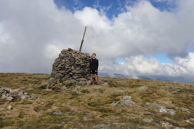
The next morning we got ready to introduce the bronzies to off track walking and navigation as we were to head up Paddy's Peak (549m) and follow the ridge roughly the way we had come in yesterday down to Mount Barney Creek. After some navigational training pairs took turn navigating us towards the peak. The final slog to the summit with the full hiking pack was arduous for some though they were rewarded with lunch at the top as well as some views towards Mount May where I had done my first dukes trip and of Mount Maroon. The ridge also provided views of Mount Barney (pictured) though it was unfortunately covered in clouds. We ended the day by cutting down off the ridge back onto the fire trail we were on yesterday and into our camp on Rocky Creek where we had a swim in the freezing water before settling in for the night.
The remainder of the trip was to be centred around the idea of a solo where in a controlled environment (some private property on the edge of the national park) the students would be separated and spend roughly 20 hours camping alone overnight. I was given a position at the far end with students dispersed between myself and the teachers. My position at the corner or Dryan's Hut Road and Seidenspinner Road offered views of Mount Maroon, Mount Barney, Mount Ernest, Mount Lindesay and Mount Gillies as well as there being a small dam in the paddock I was in. Ultimately I had a fairly cruisy few hours which involved enjoying the views, trying to remove cobblers pegs and spear grass from yesterday's hiking socks, cutting the long grass around my camp down to size with some hand scissors (what I had the time) and a whole lot of sleeping.
It was interesting to come back on this trip and see how much things had changed just in the few years since I had been a bronzie as far as trip organisation and safety regulations as well as experiencing the role I would be filling for the rest of the year for the first time.
Residential Mount Barney & Mount Maroon: 28th of August - 1st of September 2020
This five day trip with the Silvers would end up count as a residential for my own award. This trip is rightly billed as the most physically demanding of the current trip roster as over the five days we would climb both Mount Barney East Peak (1353m) and Mount Maroon (966m) (pictured) as well as negotiating the ridges between them, visiting Cronan Creek Falls and going up Yellowpinch (392m).
Thirty-Eight days later and I was back at Mount Barney National Park and back on a dukes trip this time with the silvers. I was assigned to an all boys group the first single gendered group I had been on during dukes and the vibe was definitely different. Straight away you know some ludicrous things went on during this trip some of which will not be committed to paper. We set off from the Yellowpinch carpark heading for Burbank Bush Camp which would be our home base for the first two nights. When we got there we dropped our packs and headed straight off for Cronan Creek Falls. The falls were freezing but that didn't stop a fair amount of us from jumping in and throwing the football around. In fact the football was a near constant feature of the first days walking constantly being tossed around or a grubber or chip would come from the back of the group to the front. When back at Burbank an early night was on the cards as the mighty Mount Barney awaited us in the morning.
Once awake we didn't waste time getting going heading straight for the South-East Ridge to start climbing. The boys climbed at a good pace and I ended up inheriting the pack of one of the supervisors who was having back troubles. It's been a while since I mentioned 'Ling' the 3.5kg rock and yes he has been on every expedition and in fact he was even in my day pack which was inside the supervisors day pack going up Mount Barney on my back. Now I could've left Ling down at Burbank with my tent but that would've been cheating and besides the looks at the summit when I pulled him out of my pack were worth it. After having a bite to eat and enjoying the views we continued down towards Rum Jungle a campsite in the saddle between Mount Barney East Peak and the impressive West Peak (1358m). West Peak though taller is actually the less visited peak due to less impressive views from the summit and requiring a longer journey to reach but the view of West Peak from East Peak certainly piqued my interest and is somewhere I definitely want to come back to. Some of the boys who were running low on water refilled from the creek in the saddle on our way through to our decent route, South Ridge which is also known as Peasant's Ridge due to it being the easiest way up or down the mountain. The way down Peasant's Ridge was less exposed and less scenic though allowed for a quick decent to camp. After our whirlwind trip up and down the mountain the rest of the afternoon was spent at camp.
Day three was our day of transit moving from the foot of Mount Barney we would be traveling to the foot of Mount Maroon in the North of the park. Initially we retraced our steps back out to the Yellowpinch Reserve carpark making a quick stop to go up Yellowpinch itself and enjoy the views of Mount Barney. We then continued on a ridgeline, along the way passing one of the girls groups who was doing the trip in the opposite direction to us as well as saw some bushfires out to the East. Coming down of the far end of the curving ridgeline deposited us on the Lower Portals Track which we followed to the carpark. From there we cut across to Dryan's Hut Road and to the campsite on Mount Barney Creek.
The next day we continued onto Paddy's Plain campsite as I had in the previous trip though this time we would not be staying the night. We were to continue up the sloping backside of Mount Maroon using a rough track that started up an open rocky slapped creek bed before crisscrossing a vegetated drainage gully up to the plateau before finally tackling the final ascent up the rocks to the summit. The views from the top were stunning looking South over the entirety of Mount Barney National Park with the added bonus of being able to look back across at the East Peak of Mount Barney knowing we had been standing atop it only 2 days prior. Also to the North the bowl like plateau of Mount Maroon was captivating with its mix of white rock and lush green trees. This captivating scene also proved a joy to walk through as the forest had a fairy-tale like quality to it as we passed through it on our way to the main summit track that tackles the steep North side of Mount Maroon. The initial decent off the plateau via a steep chimney was highly enjoyable before a slight traverse to the steep ridge descent which has a fair amount of loose rock and is a bit less enjoyable. Luckily at the end of this was our campsite for the night Kingsland. The site was situated beautifully with a great view of Mount Maroons imposing North Face, less pleasant was the maintenance of the site as it was decidedly overgrown. As this was our last night and we only had a short walk down Cotswold Road to where we were being picked up in the morning there was a celebratory mood in the air. This was only helped when our guide's girlfriend who lived nearby dropped off some hot chips wrapped in butchers paper. We then watched sunset and saw Mount Maroon's Northern cliff face change colours with the light. Now I haven't kept you updated with this trips nightlife but rest assure plenty of fun games were played the highlight being Fight Club. I'm unsure as to which night the first fight club occurred though it must've been either the first or second night but what I do know is that the main event occurred on the final night. The arena was the overgrown knoll beside our tents, the rules was to not be wrestled to the ground or pushed outside the area and everyone was participating in this giant free for all. Needless to say we all got a goodnights sleep.
The final day was meant to be a quick and easy stroll to the end of the road but ending up taking a bit longer than anticipated. Our patience was tested when due to a communication break down our ride arrived a few hours late. Low on water struggling to find shade on the side of the road wasn't the ideal end to the trip but the mix up wasn't bemoaned too much thanks to the good mood everyone was in thanks to the last four days amazing adventures.
Qualifying Gold Trip Upper Noosa River: 4-8th of September 2020
Only three days later and I was off again, this time to complete my final gold expedition. Now originally both gold expeditions were meant to occur on white water rivers in New South Wales but due to COVID closing the state border we had to settle for the still tannin stained waters of the Upper Noosa River located in the Cooloola Section of Great Sandy National Park. As this was a smaller trip consisting of about a dozen of us only a minibus with a small trailer for gear was needed to transport. Our journey would start and end at Elanda Point on Lake Cootharaba as we would head up into Fig Tree Lake then through The Narrows and on up the Upper Noosa River before return the way we had come. Now this was a very easy and leisurely trip and although it was nice it was a bit of an anticlimactic final expedition. The first day consisted of only 6.5kms of paddling to our campsite at Fig Tree Point and although, shallow Lake Cootharaba had a bit of chop due to it being windy, it was still a breeze. Luckily our campsite for the night was the perfect spot to kill some time. Fig Tree Point campsite resides on Fig Tree Lake and is one of the nicest campsites I've had the pleasure of spending a night at. It is accessible via the water or by walking in via the Cooloola Wilderness Trail and is home to a jetty with lovely views of the lake and the short 400m Melaleuca Circuit for stretching your legs. The jetty proved to be the favourite spot to relax and enjoy the sunset.
The second day would again prove cruisy as we were to cover 12.7km over the day. We began by heading through The Narrows which was a pretty section of river that was as wide as the name would suggest. The end of The Narrows was signalled by Harry Springs Hut and the surrounding day use area which was busy with people. So we quickly continued on further up the river. We passed by campsites 1 and 2 making our way to Campsite 3 which would be home for the night. This was a nice campsite but not quite at the level of Fig Tree Point. The rest of the afternoon was spent swimming in the river.
Early the next morning a friend and I noticed one of the canoes had come adrift from it's mooring so we set off to collect it (pictured). There is something about being on the water in the early morning when there's a slight layer of mist just clinging to the surface that is quite magical. Our quick mission on the water would actually be the only time we were on the river that morning as instead a hike was planned from Camp 3 up to the Cooloola Sandpatch. This hike is actually along a section of the Cooloola Great Walk and you could see why the sandpatch was a big one and offered stunning views out to the ocean as well as inland. The plan for the afternoon had been to paddle as far up the Noosa River as possible but a large number of the group had adjusted to the laid back Cooloola lifestyle and rather fancied a leisurely paddle so we only made it as far as camp 8 or 9 before turning back and settling into another night at camp 3.
Day four was the mirror image of day two so just 12.7km to paddle and now we had the flow of the river with us as well. Needless to say it didn't take too long to return to Fig Tree Point Campsite even with an extra passenger. At Harry's Hut we swapped around canoes to mix up paddling partners and I ended up paddling with one of the other boys in his canoe. Not long after we recommenced paddling I noticed a rather large spider in the canoe. Now when I informed the other boy of our stow away he abandoned his own ship and left me to paddle alone, cheers for that. The spider was named Walter and I ended up paddling him back to camp by sitting on the edge of the canoe or using a stand up paddle boarding technique. Once back on dry land we were finally able to remove big Walter from the canoe by flooding the canoe in the shallow water which eventually caused Walter to swim away into the reeds. Walter was identified as an Australian Giant Water Spider which is one of the largest spiders in Australia with a leg span up to 18cm. This wasn't the only animal encounter of the afternoon though thankfully the next was slightly cuter than Walter. After we set up our tents an Australian Golden Whistler was noticed in a small tree by one of the teachers who managed to gain the attention of the little bird by playing Golden Whistler noises through an app in her phone. The little bird was very interested and engaged in a wide array of bird calls much to our delight. There was still plenty of the afternoon remaining and everyone was just sitting around camp so I managed to rope another boy and a guide into an afternoon paddle out to Lake Como (no not the Italian one). We reached the far end of the lake before returning through what we we dubbed the Narrow Narrows which was a maze of small watery channels just wide enough for a canoe to pass through. We returned late in the afternoon just in time to join everyone down on the Jetty for what would be the final sunset of our Dukes journey.
We were greeted by a very windy final day which slowed our crossing of Lake Cootharaba slightly by causing us to hug the shore line more than usual though it wasn't long till we rounded Mill Point and could see the finish line in sight. Pulling into Elanda Point was an odd feeling as although it was the last trip of my personal award journey and meant the completion of my Gold Duke of Edinburgh I had another Dukes trip only a ten days later.
Moreton Island: 18-21st of September 2020
Back again on Moreton and back again on a Dukes trip only ten days removed from my last. This trip I would travel the opposite direction than I did last time heading North up the beach before heading to the Eastern side of the island and heading South before once again crossing the island and heading North back to The Wrecks. The first day was a short jaunt up the beach to Comboyuro Point featuring a less than spectacular sunset (pictured) due to a brief shower that passed over us just as we were having dinner and planning to watch the sunset. The second morning was relaxing as we only planned to set out in the afternoon as to summit Mount Tempest (280m) for sunset. This sunset more than made up for the previous days lack lustre one and thanks to setting off later the telegraph track was much more manageable. The trek down the Eastern beach on the third day was a bit hot and uncomfortable but migrating whales offered a distraction putting on a show for us and traveling alongside us for a fair distance. At Rous Battery as a captain it was now my turn to traumatise a future generation of dukies by jump scaring them from each dark corner. The final days hike is a long one and though I would suggest that going this way around the island may improve the first two days walking it is to the detriment of the final days walking (first day for other direction). While the distance is the same length being able to walk the majority of it at night is a blessing for this walk as, The Desert is more enjoyable at night as your not being burnt alive plus it makes for a good place to look at stars and there isn't a whole lot to look at on the Rous Battery Track so you don't lose any views by doing it at night. Ultimately my final dukes trip as a student was yet again a delight but you do lose a certain sense of adventure when your not visiting somewhere new.
Extra
Upper & Lower Portals: 26-29th of August 2021
I would have to wait almost a year later till my next dukes trip which would prove to be a fresh adventure in a national park I knew well. This was a multi-purpose trip with the gold dukies to arrive on the first day where we would do leadership training with them at Mount Barney Lodge and try out some rock climbing (honestly not really my thing I love the outdoors but clinging onto the side of a cliff ain't it) then on the second day the silver dukies would arrive and we would commence a three day journey traversing Mount Barney National Park East to West.
The first night after the leadership training had concluded was freezing abnormally so. Now don't get me wrong Mount Barney can get cold during winter but this was something else compared to any of the other nights we experienced. Temperatures must've dropped to zero or potentially negative and my summer sleeping bag which had lost the ability to zip up long ago simply wasn't cutting it. I spent the night shivering and as soon as the sun came up I was out of my tent trying to get my blood flowing to warm me up. Due to my particularly early rise I did get to witness some nice light on Mount Barney (pictured), my silver Lansan Ultralight Tent is pitched amongst the tents of the rest of the dukies.
The silvers arrived midmorning and it wasn't long before we had them packed and back on a bus to the lower portals car park. On this trip I again had an all boys group which would be heading East to West across the park. Starting out along the lower portals track we quickly reached the icy waters of the portal which although no one was keen for a swim were still enjoyed for their scenic beauty as we had lunch. Back tracking slightly we left the path and set off into the bush beginning the climb to the ridgeline. A dusty goat track was discovered which despite being slippery under foot allowed us to reach the crest of the ridgeline with relative ease. To reach the Barney Gorge Junction remote bush camp we contoured around into the gully then followed it down to the creek. The site had a dirt base which is never my favourite to camp on because the dust gets everywhere. It wasn't all bad though as there were some big rocks scattered amongst the tent sites as well as the beautiful Mount Barney Creek running beside it. A big boulder in the middle of Mount Barney Creek made for a spectacular spot to enjoy spotting some shooting stars while wrapped in our sleeping bags late at night.
The following morning consisted of a steady climb up to the top of Cleared Ridge (768m) before dropping back down to reach the trail to the Upper Portals. When the trail was reached we dropped our main packs and descended to the Upper Portals to have lunch. Of the two portals I would have to say upper is my favourite thanks to the waterfall and it's more remote setting (we had it to ourselves). A brave few of us dared to swim plunging in before quickly retreating to sun bake on the rocks like lizards. After an enjoyable hour or two at the Upper Portals we returned to our packs and made our way off the opposite side of the ridge to the Yamahra Creek remote bush camp. This campsite was situated on the grassy banks of Yamahra Creek just up stream from where it joins Mount Barney Creek. An early night was taken as we were going to attempt to climb Montserrat Lookout (1013m) for dawn the next morning.
500 vertical metres first thing in the morning is always going to be tough and it wasn't made any easier by the shrubbery at the beginning of the South Eastern ridge. Your boot would plunge about a foot into the undergrowth before reaching the uneven surface of the ridge. This was hard on both your ankles and knees and really took a bit of steam out of us but thankfully once we got up onto the ridge proper the going was easier. We managed to reach the rock slab on the summit and witness the sun rise over Mount Barney while enjoying a well earned breakfast. The return journey back down the mountain to the campground was unsurprisingly a lot easier. After backing down camp we began the hike out along the fire trail. We passed by the Hoop Pines remote bush camp which was nestled in a grove of the stunning trees and is definitely somewhere I would love to come back and spend a night. Our last climb of the journey began as we left the valley floor and made our way up onto the Cleared Ridge to meet Waterfall Creek Road. This road we would follow down to the Waterfall Creek Campsite which is where years ago I had my very first Dukes trip and along this section of road the beginning of my first dukes hike. So the final few kilometres of this trip really was just one long stroll down memory lane.
Moreton Island: 17-20th of September 2021

Back again, third times the charm they say and this trip proved the old saying right. Although there wouldn't be any first time excitement of visiting a new place on this trip a return to my favoured route around the island (South - North - South) was welcomed. The trip began with the familiar bus ride up the M1 and ferry across Moreton Bay and our island arrival routine of running up the big sand dune (pictured). Our group set off South past the Tangalooma Resort battling a rising tide which required us to time our runs along the narrow stretch of beach between each wave. Reaching our inland turn we watched sunset over the ocean and preceded into The Desert. Being back in The Desert at night was an exhilarating feeling, free from the oppressive sun we tore down the sand dunes running though the cool night air. We spent a long time playing on the dunes before we began the obligatory trudge along the Rous Battery Track. We made good time through to camp.
I slept in that morning which is very rare for me when I am camping as I am usually up as soon as the sun is. This day I would be tasked with leading a group North up the far beach to the nights camp. We made it up the long stretch of beach with no causalities and with everyone in good spirits. Once at camp we played touch on the beach for the rest of the evening and once it was dark I led some games of mafia.
The third day saw us traverse back to the Western side of the island using Middle Road and the Telegraph Track with a stop of at Mount Tempest (280m). Thankfully the day wasn't too hot so it was rather enjoyable even if the Telegraph Track was seemingly more overgrown than when I had last walked it. I was again tasked with leading a group and the day was passed with traditional Dukes riddles such as the triangle game. Comboyuro Point campground once again proved a blessing as a good time was had by all on the beach swimming, playing touch, watching the sunset over the mainland and long chats under the stars.
The final day we passed and kicked the touch football around the whole way down the beach running after grubbers and chip kicks with full hiking packs. The ferry ride across Moreton Bay to the mainland was as bitter sweet as ever.
Conclusion
My experience with the Duke of Edinburgh's Award was overwhelmingly positive and would have to go down as one of the best things I have undertaken in my life. It was an avenue for growth through the building of character and a discovery of a passion through the journeys undertaken. As I am writing this I leave tomorrow for a 2 and a half week road trip of Central Queensland so stay tuned for recap of that adventure coming to Somewhere Out There sometime in the future.


Comments
Post a Comment