Context
Some months ago, I was wondered how many national parks I had visited. The answer was 30 something back then. Deciding that wasn't nearly enough the quest to visit 50 began. This is the culmination of that quest: Ranking The First 50 National Parks.
Now I could've ranked them by size or by biological diversity but I decided to rank them by the completely subjective measure of my personal experience. So yes, the list is completely pointless and purely a matter of opinion and personal preference but hey that's what makes it fun. In fact, it was this very idea that made me think maybe I should make a blog because what's the point of making a potentially divisive list without putting it on the internet for people to argue over. So, I encourage you to argue and create your own ranking of the National Parks you have visited (great fun for when your not on the trail). Without further ado join the expert in a completely factual and unopinionated ranking of 50 almost random National Parks by no particular means just vibes (I lie there was actually a lot of thought behind the choices).
*Note I'm excluding any National Park I may have visited in the 2007/08 overseas trip as it was too long ago*
The Break Down Of The 50
Australia 49
49/685 AUS NPs Visited 7.15%
Queensland 24
24/237 QLD NPs Visited 10.13%
New South Wales 20
20/235 NSW NPs Visited 8.51%
Victoria 4
4/45 VIC NPs Visited 8.89%
Tasmania 1
1/19 TAS NPs Visited 5.26%
New Zealand 1
1/13 NZ NPs Visited 7.69%
Ranking The First 50 National Parks
#50
Nerang National Park (QLD)
One of Queensland's newer national parks a convert from a State Forest in 2009. The 1,614 hectares of pleasant but uninspiring bushland culminates at
only 253 meters above sea level. The highlight of the park would have to be that it hosted the Gold Coast's 2018 Commonwealth Game's mountain bike events on its mountain bike trails though unless you're a mountain biker not too much to offer. Finishes last even though its large and user friendly it's just a bit boring.
#49
Mallanganee National Park (NSW)
Established in 1999 and located opposite Richmond Range National Park on the South side of the Bruxner Highway this 1,144ha park's main visitation point is the Mallanganee Lookout (pictured) which sits on the very edge of the park and offers reasonable views, picnic tables and some interpretive signs. There are no walking trails but are some management trails in the dry rainforest of the park that I didn't get to thus keeping it off the bottom of the pile besides the views I saw from the lookout topped anything in Nerang.
#48
The Palms National Park (QLD)
Established in 1950 this tiny 12.4ha park is home to you guessed it a lot of piccabeen palms. A short board walked loop takes you through the waterlogged depression which plays host to this environment that is unique to the area. Securing #48 due to the quirky spectacle this little park displays and due to it having the first designated and purpose-built walking trail of the list (even if it's only 700 meters) compared to Nerang and Mallanganee management trails.
#47
Ulidarra National Park (NSW)
Established in 1999 this park reminds me of a better version of Nerang National Park though only 680ha the park is higher (442 meters at the brilliantly named End Peak) and thus is wetter providing habitat to lusher rainforest and thus the management trails that traverse this park are more enjoyable. Though there are limited views from the aforementioned End Peak the view pictured is from the Forest Sky Pier South over Coffs Harbour which is just outside the park though is part of park experience as you leave from the carpark behind it to walk along the ridge to End Peak.
#46
Cunnawarra National Park (NSW)
Established in 1999 this 16,315ha swath of wilderness only has one facility which a 4wd is required to reach. This facility is the Beech Lookout which is perched 1370 meters above sea level and overlooks some of New South Wales's tallest trees forest ribbon gums reaching 70 meters tall which reside in the valley below (pictured). The park also lies within the UNESCO Gondwana Rainforests of Australia World Heritage Area. Despite its lack of facilities, it's the promise of pristine wilderness adventures for the intrepid explorer that cements it's place at #46 even if I only got a taste from the Beech Lookout.
#45
Tewantin National Park (QLD)
The high point of this 1,300ha park in both senses of the word is the 265m volcanic plug known as Mount Tinbeerwah (pictured). This peak offers vast views over the coastal lowlands though as seen in the photo when I was there it was wrapped in rain clouds which offered an otherworldly experience so despite the lack of a view, I wasn't left disappointed.
#44
Koreelah National Park (NSW)
This 5,270ha park hugs the Queensland border at the Southern terminus of Main Range and is part of the UNESCO Gondwana Rainforests of Australia World Heritage Area. Established in 1999 the park's main draw cards are the Koreelah Creek Gorge (pictured) with its small waterfall and nearby Koreelah creek campground.
#43
Curtis Island National Park (QLD)
I visited this park back in 2010 with my grandfather on his boat the picture is of Sea Hill which is the Western tip of Curtis Island and outside the National Park as I cannot find photos of Yellow Patch which is a sand dune within the National Park we ventured to the next day. The national park which encompasses part of the Eastern side of the island and the surrounding conservation parks protected around 25,000ha of the island. The island lies within the Southern region of the Great Barrier Reef World Heritage Area.
#42
Tooloom National Park (NSW)
Established in 1995 this 4,380ha park is part of the UNESCO Gondwana Rainforests of Australia World Heritage Area. Sitting up on the range the roadside Tooloom picnic area offers access to the Tooloom lookout (pictured) which looks over the road to the West via a short walk through the rainforest as well as a short loop through the rainforest with lots of interpretive signage.
#41
Tuchekoi National Park (QLD)
This 3,900ha park features Mount Cooroora 439 meters which plays host to the annual King of the Mountain race. The route to the top is steep and involves some scrambling though stairs and handrails have been built in places. Views from the top stretch out in all directions including to the Pacific Ocean at Noosa (pictured).
#40
Burleigh Head National Park (QLD)
Burleigh Head
(pictured) is an eighty-meter-high volcanic headland at the mouth of Tallebudgera Creek that is the centre piece of this 27.6ha park established in 1947. Tumgun Lookout offers stunning views South while the colloquially termed cock rock also provides stunning views and for a refreshing dip try the slightly more secluded but often still busy Echo Beach on the Southern side of Burleigh Head.
#39
St. Helena Island National Park (QLD)
Finally, we make it to a park that I don't have any photos of as my only visit to the park was on a year 5 excursion back in 2013. St. Helena Island is located in Moreton Bay and is the site of Queensland's first penal settlement. The impressive ruins take prized place in the centre of the small island which was established as Queensland's first historic national park in 1979.
#38
Tambourine National Park (QLD)
Queensland's first National Park with the original Witches Falls section established in 1908 before expanding to 14 sections covering 1,160ha. The many sections scattered across the Mount Tambourine plateau (578 meters at its highest point) play host to an array of short walking tracks featuring rainforest and waterfalls. Although not the wildest or remotest these pretty little pockets of rainforest do provide bang for your buck. Curtis Falls pictured.
#37
Capricorn Coast National Park (QLD)
My only photo of the Capricorn Coast National Park is from 2010 on an old iPod touch and the composition is slightly off centre but oh well better than nothing. Capricorn Coast National Park was established in 1992 and is another park divided into little sections, six in this case covering 114ha. The sections are situated mostly around volcanic headlands up and down the coast with the four main sections being Double Head, Rosslyn Head, Bluff Point & Cocoanut Point (Yes that is how its spelt). The photo in question is of Bluff Rock from Kemp Beach which is on the Northern edge of the Bluff Point Section.
#36
Naree Budjong Djara (North Stradbroke Island) National Park (QLD)
North Stradbroke Island or Minjerribah to the Quandamooka people is the second largest sand island in the world. The Naree Budjong Djara (My Mother Earth) National Park was established in 2011 and covers 1,322ha of the island with expansion plans in the works. The park's main features are freshwater lakes and small sandy peaks. Pictured is Swan Bay at the Southern end of the island.
#35
Noosa National Park (QLD)
Established in 1939 Noosa National Park consists of 4,000ha in multiple sections between Noosa and Coolum. The famous coastal walk runs from Noosa to Sunshine Beach in the Noosa Headland section taking in the stunning bays of Tea Tree Bay, Granite Bay (Pictured) and Alexandria Bay as well as the wave carved Fairy Pools, Hell's Gates, Devil's Kitchen. The coastal peaks of Emu Mountain (also known as Mount Peregian) at just over 70m of elevation offers the views while the highest peak in the park Noosa Hill 146m is viewless.
#34 D'Aguilar National Park (QLD)
D'Aguilar National Park
established in 1938 protects 36,000ha of the D'Aguilar Range's woodlands, subtropical rainforest pockets and peaks. As Brisbane's closest national park, it is well maintained with many walking tracks, 11 national park campsites and plenty of visitor amenities. At 770 meters Tenison Woods Mountain is the range's highest peak while the walk to the eponymous Mount D'Aguilar passes the wreck of an airplane crash. Secrets hide in the valleys as well from the Northbrook River Gorge to the Rocky Hole in the more remote Northern section which includes the Gantry and the well-known Somerset Trail. While not the most spectacular the vastness and quantity of adventures possible propel this national park up the list.
#33
Bundjalung National Park (NSW)
A combination of my visit predating my ownership of a camera, the failing light and transferring the photo through Facebook messenger leaves this photo of Woody Bay just barely better than having none at all. Bundjalung National Park established in 1980 covers 21,207ha on the North Coast of New South Wales between Evans Heads and Iluka. Water paths exist along the Esk River, Jerusalem Creek & Evans River for canoeing and kayaking not to mention the vast stretch of Pacific Ocean. Formed hiking trails are also present at Jerusalem Creek and at Iluka Bluff while isolated beach are also perfect places for feet to tread.
#32
Boonoo Boonoo National Park (NSW)
Established in 1982 Boonoo Boonoo National Park covers 4,377ha and is centred on the Boonoo Boonoo River which runs through the centre of the park before tumbling 210 meters off the tablelands at Boonoo Boonoo Falls (pictured). This is supposedly where famous Australian poet Banjo Paterson proposed to his partner Alice Walker and managed to lip read a yes over the sound of the crashing water. Throw in some gold mining history upstream at Morgan's Gully and collections of rock pools to swim in such as the Platypus Hole and you've got Boonoo Boonoo National Park in all it's glory.
#31
Cathedral Rock National Park (NSW)
Cathedral Rock National Park covers 10,897ha of the Snowy Range in the New England Tablelands and was established in 1978. The highest peak in the park Cathedral Rock reaches 1563m and sits across from the highest peak in the Snowy Range, Round Mountain 1586m whose summit is occupied by air services Australia. Two campgrounds exist in the park Barokee Campground which is South of Cathedral Rock and Native Dog Campground which is in the North of the park near Woolpack Rocks.
#30
Gheebulum Kunungai (Moreton Island) National Park (QLD)
Moreton Island known to the Quandamooka people as Mulgumpin has been preserved as Moreton Island national park since 1966 though in 2021 the name was changed to Gheebulum Kunungai (Moreton Island) National Park with Gheebulum Kunungai translating to lightnings’ playground in the local language. World War 2 battlements were set up around the island to protect Moreton Bay and the Port of Brisbane these battlements remain in many locations with good examples present at the Western beaches at Cowan Cowan and at Rous Battery. Mount Tempest (Moogar Bippo) (pictured) is thought to be the highest vegetated (stabilised) sand dune in the world. The park covers 16,900 hectares.
#29
Bunya Mountains National Park (QLD)
Bunya Mountains National Park is home to the largest stand of Bunya Pines in the world as well as 119 native grasslands known as balds (pictured). It was declared a national park in 1908 becoming the state's second and now protects 19,600ha. The range peaks at Mount Kiangarow 1154m which is home to some of the tallest Xanthorrhoea (grass trees) in the world which are at least several hundred years old. On the East side of the range a trail network takes you through Bunya Pines, balds and past waterfalls while the trail network on the Western side takes you along the cliff edge with views that stretch out to the horizon.
#28
Yuraygir National Park (NSW)
Created in 1980 by merging Angourie and Red Rock National Parks the modern day Yuraygir National Park stretches from Angourie Point to Red Rock and encompasses 35,521ha of the New South Wales North Coast. Many short walks exist but it's the longest that may just be the most famous the Yuraygir Coast Walk runs the length of the park along the Pacific coastline the 65kms takes 4 to 5 days to complete.
#27
Wollumbin (Mount Warning) National Park (NSW)
Wollumbin (Mount Warning) 1157m is the remnant central plug of the extinct Tweed Volcano which has the largest erosion caldera in the Southern Hemisphere with a diameter of over 40kms. Established in 1967 the national park covers 4,117ha around the peak. The summit track is 8.8kms return to the top through numerous switch backs and a chain section at the top. The park has been closed for a few years due to multiple ongoing disputes and remains to be seen if it reopens. Luckily, I visited before the closure began and climbed Wollumbin on my school's year 8 camp back in 2016.
#26
Glass House Mountains National Park (QLD)
This collection of distinctive volcanic plugs rise from the coastal lowlands and are impossible to ignore when travelling through the region. Originally parks were gazetted around individual peaks before amalgamating the sections under one name as the Glass House Mountains National Park in 1994 which covers 883ha. Mount Beerwah (pictured) is the tallest of the Glass House Mountains at 556 meters. The summit routes of Mount Beerwah and the second highest mountain Mount Tibrogargan 364m are well known to be steep rock scrambles.
#25
Moogerah Peaks National Park (QLD)
Moogerah Peaks National Park slips into the top half of this list controversially edging out the Glass House Mountains National Park. It was a tight call that might be reversed by the time I visit 100 parks and put out the next iteration of this list but what saw this park across the line was its lower visitation numbers, higher peaks and its idyllic position on the shores of Lake Moogerah in the middle of the Fassifern Valley with the scenic rim wrapping around the horizon. Moogerah Peaks National Park as it is known today comes as the result of an amalgamation of smaller parks in 1994 to cover 676ha around the peaks of Mount French 598m (pictured), Mount Edwards 634m, Mount Grenville 770m and Mount Moon 786m.
#24
Crows Nest National Park (QLD)
On a trip out to the Bunya Mountains it was Crows Nest National Park first protected in 1967 that really impressed. The jewel in the crown of this 1,790ha park is the Valley of Diamonds so named for the mineral feldspar which glistens as if it were diamond. This captivating valley is punctuated by Crows Nest Creek which drops 20m over Crows Nest Falls into the valley as well as containing many cascades upstream (pictured). This unique landscape only approximately 2 hours and 20 minutes from the Brisbane CBD feels as if you should've had to drive at least a day into the outback to discover this oasis.
#23
Nightcap National Park (NSW)
Home to the 100m tall Minyon Falls (pictured) this 8,080ha park gained its national park status in 1983 after a three-year protest dubbed the rainforest war (there is even a waterfall named in their honour; Protesters Falls). Along the rain forested spine of the park the Historic Nightcap Walking Track runs for 18km one way and the Goorgana Walking Track provides a 18km out and back trip in the other direction. A declared UNESCO Gondwana Rainforests of Australia World Heritage Area Nightcap National Park's ancient landscape is sure to take your breath away.
#22
Dorrigo National Park (NSW)
Another UNESCO Gondwana Rainforests of Australia World Heritage Area wonderland, Dorrigo sits on the edge of the escarpment and is often the first stop on the famous Waterfall Way tourist drive when approaching from the coastal side. Like the name of the tourist drive suggests there are plenty of waterfalls some of the more well-known being Crystal Shower Falls, Tristania Falls, Red Cedar Falls & Coachwood Falls on the gorgeous Rosewood Creek (pictured). Somehow tired of the waterfalls that lie under the rainforest canopy then break into the sunlight by rising 21 meters above the ground on the 70-meter-long Skywalk Lookout to take in views over the Rosewood Rainforest Basin. This 11,902ha national park was established in 1967 though conservation in the area began in 1901.
#21
Bald Rock National Park (NSW)
The eponymous Bald Rock is the largest granite monolith in the Southern Hemisphere, this staggeringly big rock tops out at 1277 meters above sea level and is 500m wide and 750m long. This 8,883ha park has been protected since 1971 and doesn't just house one bald rock with Little Bald rock still a respectable 1223m high, as well as many other granite features scattered throughout the park.
#20
Basket Swamp National Park (NSW)
The epitome of a hidden gem this park has little information available but a lot to offer. The beautiful Basket Swamp Falls (pictured) were perhaps helped by recent rain but I still couldn't believe they weren't more widely regarded perhaps I had stumbled onto a local secret. The park wasn't a one trick pony either, further waterfalls resided upstream and the granite peak of Timbarra Trig Lookout provided astonishing views and a tight scramble to the top. Woollool Woolloolni Aboriginal Place also known as Wellington Rock is a distinctive granite outcrop and even the Basket Swamp itself was pleasant. This 2,820ha park created in 1999 exceeded all my expectations and helped disband the negative connotations I had connected to the word swamp (it just doesn't sound inviting, does it?).
#19
Border Ranges National Park (NSW)
At #19 we return to the UNESCO Gondwana Rainforests of Australia World Heritage Area with the Border Ranges National Park. Founded in 1979 this 31,729ha tract of ancient rainforest lies on the Western edge of the Tweed Volcano Caldera stunning views of which are available at the pinnacle lookout. While spectacular views Westward are afforded from Bar Mountain Lookout. The park isn't all about views though with the pretty Brindle Creek crisscrossed on little wooden footbridges straight out of a fairy tale before reaching Evans Falls, then the sublime Selva Falls and finally the off-trail Swanson Falls (pictured). While Sheepstation Creek plays host to potentially the parks most well-known and easily accessed falls, Brushbox Falls.
#18
Keppel Bay Islands National Park (QLD)
Established in 1994 the 13 island included in the Keppel Bay Island National Park are part of the UNESCO Great Barrier Reef World Heritage Area. The 720ha of idyllic island paradise offer the real possibility of having an island to yourself with small campsites on Conical, Divided, Hummocky, Humpy, Miall, Middle (Pictured) & Pelican Islands where you can get a feel for what it would be like to be a castaway. As well as camping on the Keppel Groups second largest island of the 18 islands in the group North Keppel Island (627ha) which is the largest in the national park and second only to Great Keppel Island (1,454ha).
#17
Port Campbell National Park (VIC)
The first national park on the list not from New South Wales or Queensland, Port Campbell National Park is home to many Great Ocean Road icons including the Twelve Apostles (pictured) which never actually had 12 and has even less now due to erosion. Established in 1964 the park covers 1,830ha of coastline around the town of Port Campbell.
#16
Springbrook National Park (QLD)

An impressive national park to be able to call my local Springbrook is part of the UNESCO Gondwana Rainforests of Australia World Heritage Area. The first section of the park was established in 1937 the modern-day Springbrook National Park covering 6,558ha was created from the amalgamation of the smaller parks in 1990. The park peaks at Mount Mumdjin 1021m at the South Western corner of the Springbrook Plateau and is separated from Lamington National Park by Numinbah Valley it also forms the Northern boundary of the tweed volcano caldera. A truly special vista of the caldera can be gained from Best of All Lookouts on Mount Mumdjin. The park is home to many well-known waterfalls such as Natural Bridge, Cougal Cascades, Twin Falls & the epic 100m Purlingbrook Falls (pictured). The park also offers volcanic peaks to scramble up such as The Springbrook Pinnacle, Pages Pinnacle & Mount Cougal East & West. Springbrook is also home to the renowned 17 km Warrie Circuit and the final section of the 54km Gold Coast Hinterland Great Walk.
#15
Main Range National Park (QLD)
The Main Range represents the Western edge of the Scenic Rim and is home to South East Queensland's highest peak Mount Superbus 1375m. The park covers a huge 30,170.5ha and is also part of the UNESCO Gondwana Rainforests of Australia World Heritage Area due to the remnant rainforest that survives there. In 1909 the first section of the current national park was created at Cunningham's Gap where Mount Mitchell 1168m (pictured) and Mount Cordeaux 1146m stand sentinel on either side of the gap. In 1980 the smaller parks were amalgamated into the park we know today. Among the many peaks the legendary rock formation of The Steamers remains an off-track pilgrimage point for walkers of the region. The park is also home to the waterfalls of Queen Mary Falls, Araucaria Falls & Gap Creek Falls as well as the long-distance trail the 47km Scenic Rim Trail.
#14
Great Sandy National Park (QLD)
This vast national park occupies two sections K'gari (Fraser) Island the world's largest sand island which is also home to half the world's perched freshwater dune lakes and thus has been designated K'gari (Fraser Island) World Heritage Area by UNESCO and on the mainland, there is the Cooloola section. The origin of the park can be traced back to 1971 when the first section of national park was declared
in the Northern part of Fraser Island the park has expanded over time now covering 219,555ha over the two sections. The park is home to many renowned lakes most notably
Lake Boomanjin the largest perched lake in the world almost 200ha, Lake McKenzie (Boorangoora) with its sparkling blue water, Lake Wabby the deepest on K'gari and the stunning Lake Poona (pictured). Two of Queensland's Great Walks lay in the park the 102km Cooloola Great Walk and the 90km K'gari (Fraser Island) Great Walk.
#13
Mount Barney National Park (QLD)
The rugged and mountainous landscape of Mount Barney National Park is home to many stunning peaks with tranquil creeks and gorges between them and remnant
rainforest pockets worthy of inclusion in the UNESCO Gondwana Rainforests of Australia World Heritage Area. The eponymous Mount Barney consists of two peaks the slightly higher Mount Barney West Peak 1358m and the more commonly visited summit Mount Barney East Peak 1353m (pictured) due to the better views. Though there is much more to the park than just the Mount Barney Massif. Mount Maroon gives stunning views as does Montserrat Lookout and Cronan Creek Falls, Upper Portals & the Lower Portals provide a challenge of a different kind with their often frigid water. The park was first gazetted in 1947 and currently covers 13,000ha of wilderness.
#12
Guy Fawkes River National Park (NSW)
Established in 1972 this 93,085ha park follows the journey of the Guy Fawkes River as it plunges off the Northern tableland via the incredible Ebor Falls (pictured) till its confluence with the Sara River at which point it turns into the Boyd River and shortly leaves the park. The park is mostly a vast wilderness with the main visitor points being Ebor Falls and Chaelundi Falls. At Chaelundi Falls there is a campground and a walk around the escarpment and to Lucifer's Thumb.
#11
Oxley Wild Rivers National Park (NSW)
Just missing out on the top ten is the wild gorge country of the Oxley Wild Rivers National Park home to New South Wales's tallest waterfall Wollomombi Falls which has a single drop of 260 metres and a total drop of 424 metres when including the continuous upper cascades according to Geoscience Australia making it one of the tallest in the country. The large 159,000ha park started coming together due to the amalgamation of smaller parks in 1986 and was included in the UNESCO Gondwana Rainforests of Australia World Heritage Area due to the extensive amount of dry rainforest that is present within the park. It is also home to the multiday hut to hut walk the 65km Green Gully Track.
#10
Tasman National Park (TAS)
The first and only Tasmanian national park on the list sneaks its way into the top 10 thanks to its stunning sea cliffs which are the highest in Australia and the Southern Hemisphere. The dolerite cliffs at Cape Pillar, Cape Raoul & Cape Hauy reach up to 300 meters above the sea below. Pictured in the foreground is The Thumbs off of Thumb Point and in the background is Cape Hauy and the formations of The Totem Pole, The Candlestick & The Lanterns. The famous multiday hike the Three Capes Track winds it's 48km journey across the top of the three aforementioned capes. The Tasman Peninsula is known to feel the full effects of the roaring forties (strong Westerly winds between the latitudes of 40-50 in the Southern Hemisphere). The imposing Tasman Island sits off the Southern end of Cape Pillar and hosts Australia's highest operating lighthouse the Tasman Island Lighthouse. The national park was established in 1999 from mostly former state reserves and covers 10,755 hectares.
#9
Alpine National Park (VIC)
Home to the highest peaks in Victoria, Alpine National Park is a stunner and with 661,375ha of alpine goodness there's a lot of it, in fact it's the largest national park in the state. I visited the park in 2021 and climbed the states tallest mountain Mount Bogong 1986m via the Staircase Spur (pictured) and then climbed the razorback ridge to the states second highest mountain Mount Feathertop 1922m before descending the North West Spur. The modern park was created in 1989 with the addition of a few areas since.
#8
Blue Mountains National Park (NSW)
Here I'm guessing is where my opinion deviates from most sane Australians putting the much loved and UNESCO recognised (Greater Blue Mountains World Heritage Area) Blue Mountains National Park in 8th. Now we are at the pointy end of the list and tough decisions must be made the Blue Mountains are undoubtedly a world class park though they all are up this end of the list. The Blue Mountains can count themselves unlucky that my only visit to the park was back in 2015 when I was 13 and only for 2 or 3 days. I barely scraped the surface of this 267,183ha park I saw the Three Sisters from Echo Point (pictured), the view from Sublime Point, the Pool of Siloam and Bridal Veil Falls. This park established in 1959 has a lot to offer and it's one I'd like to return to at some point in the future.
#7
Kosciuszko National Park (NSW)
What could be worse than putting the Blue Mountains in 8th possibly putting Kosciuszko in 7th. Now my experiences with Kosciuszko have been great fun but I haven't actually seen as much of the park as I would like my visits in 2010 and 2015 both consisted of skiing at Thredbo (pictured) with Eagles Nest at 1937m the closest I got to the roof of Australia. High on my bucket list is to return to the park to do a multiday hike which is essentially an extended version of the Main Range Track ticking off Australia's highest mountains. Kosciuszko has been a reserve of some kind since 1906 though became a national park in 1967 and now stretches over 673,524ha of the Australian Alps.
#6
Girraween National Park (QLD)
Girraween means ‘place of flowers’ though it’s likely
to be the granite formations that grab your attention. This 11,800ha park is
full of them there is the First Pyramid, Second Pyramid (pictured), Castle
Rock, The Sphinx, Turtle Rock and the tallest peak Mount Norman 1266m just to
name some of the most well-known. These peaks offer exciting scrambles and vast
views. The first national park in the area was created back in 1930 and has steadily
grown since then to the park we know today. Not only is the granite landscape found
in Girraween unique in Queensland it is also located in one of the most Southern
parts of the state and thanks to this and its greater altitude due to its
position on the tableland means it experiences some of the coldest temperatures
in the state and is one of the few places to experience snow fall.
#5
Grampians (Gariwerd) National Park (VIC)
The Grampians is a series
of sandstone mountain ranges was declared a national park in 1984 that today
now covers an area of 168,145 hectares. The stunning landscape contain 90% of
the state's aboriginal rock art as well as housing the Zumsteins Historic Area
where the remnants of a 1930s tourist retreat can be found. Mount William
(Duwul) is the highest peak of the Grampians at 1167m though the most famous peak
might be The Pinnacle 715m with its stunning view over Halls Gap and Lake
Bellfield (pictured). The walk to the pinnacle is often started at the aptly
named Wonderland Carpark or from Halls Gap and passes through the Grand Canyon
and Silent Street. Other well-known attractions include MacKenzie Falls, The Balconies,
Mount Stapylton, Hollow Mountain, Mount Zero, Chatauqua Peak & Boronia Peak.
The newly opened 160km Grampians Peak Trail runs the length of the park North
to South and takes 13 days.
#4
New England National Park (NSW)
Established in 1937 the
68,847ha New England National Park is part of the UNESCO Gondwana Rainforests
of Australia World Heritage Area. The park has great altitudinal deviation from
1563m at Point Lookout on top of the escarpment to 150m down in the Bellinger River
Valley. The multiday 33km New England Wilderness Walk experiences much of the
elevation change as it runs its course leaving the escarpment for the river
valley. Point Lookout and its breath-taking views are well renowned but make
sure not to miss the beautiful Wrights Lookout which feels like a beach headland in
the sky with clouds for waves.
#3
Lamington National Park (QLD)
The king of the UNESCO Gondwana
Rainforests of Australia World Heritage Area sites in Queensland this lush
21,176ha park came into being in 1915 and much of its 160km trail network was
constructed during the great depression (1930s). The park is home to over 500
waterfalls pictured is Ballanjui Falls. The park tops out at 1195m at Mount
Bithongabel which is the tallest point of the Tweed Volcano Caldera. I’ve had
the pleasure of visiting this park many times and it will take many more visits
before I run out of places to see. Deserving of its place on the podium.
#2
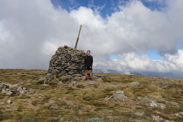
Mount Buffalo National Park (VIC)
This high granite
plateau is 31,020ha of pure wonderland with waterfalls, granite peaks, seasonal
snow, impressive cliffs and a lake. The park was created in 1898 making it one
of the oldest in the country and is home to the historic Mount Buffalo Chalet
dating from 1910. Named for its supposed resemblance to a buffalo some features
continue with the analogy from The Horn 1723m the parks highest point which
offers stunning views over the plateau (pictured) down to The Hump 1695m which
overlooks the stunning Cathedral 1654m. I came to the conclusion on my visit in 2021 that this park is undoubtably a special place
and worthy of the silver medal it would have to take something special to beat
this …
#1
Tongariro National Park (NZ)

Conclusion
So, that was my ranking of the first 50 national parks I've visited. Now the documentation of the journey to 100 begins as well as stories from the first 50 here on Somewhere Out There.


 On a trip out to the Bunya Mountains it was Crows Nest National Park first protected in 1967 that really impressed. The jewel in the crown of this 1,790ha park is the Valley of Diamonds so named for the mineral feldspar which glistens as if it were diamond. This captivating valley is punctuated by Crows Nest Creek which drops 20m over Crows Nest Falls into the valley as well as containing many cascades upstream (pictured). This unique landscape only approximately 2 hours and 20 minutes from the Brisbane CBD feels as if you should've had to drive at least a day into the outback to discover this oasis.


Comments
Post a Comment